


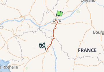
04_GR Tours - Poitiers

Lucquiaud
Gebruiker

Lengte
144 km

Max. hoogte
133 m

Positief hoogteverschil
1415 m
Km-Effort
163 km

Min. hoogte
35 m

Negatief hoogteverschil
1376 m
Boucle
Neen
Datum van aanmaak :
2018-09-15 15:01:40.902
Laatste wijziging :
2018-09-15 15:01:41.282
35h55
Moeilijkheid : Onbekend

Gratisgps-wandelapplicatie
 SityTrail
IGN / Geografische instituten
SityTrail Plus
De wereld gaat voor u open
Over ons
Tocht Mountainbike van 144 km beschikbaar op Centre-Val de Loire, Indre-et-Loire, Tours (Indre-et-Loire). Deze tocht wordt voorgesteld door Lucquiaud.
Plaatsbepaling
Land:
France
Regio :
Centre-Val de Loire
Departement/Provincie :
Indre-et-Loire
Gemeente :
Tours (Indre-et-Loire)
Locatie:
Unknown
Vertrek:(Dec)
Vertrek:(UTM)
325353 ; 5251482 (31T) N.
Opmerkingen